

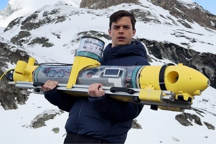
A team of engineering students from ETH Zürich has developed POLARIS, an autonomous underwater robot designed to measure and map the thickness of ice from underneath frozen alpine lakes. The idea is to make ice surveys safer and faster, especially in places where people need to know whether the ice is strong enough for activities such as racing or other work on frozen lakes. Traditionally, ice thickness is checked by drilling holes at different locations and measuring the ice manually. However, this method takes a lot of time and may require people to work in dangerous conditions. The POLARIS team tested its underwater robot during a field mission in the Swiss Alps to explore a more efficient way of collecting ice-thickness data. The development and field test were also documented in a CPSdrone YouTube video, which followed the team during its mission.
The POLARIS robot combines several technologies to move and find its position underwater. The approximately 30-kilogram submarine has six motors, allowing it to move in different directions and control its position underwater. It uses a Jetson-class computer as its main computing unit, along with sonar, GNSS/RTK, pressure sensors and underwater acoustic positioning. Because GNSS signals cannot normally be received when the antenna is submerged, POLARIS uses Short Baseline (SBL) acoustic positioning for underwater localization. In this method, sound signals from a beacon on the submarine are received by hydrophones, helping the team estimate the robot's location. The robot also carries a GNSS/RTK antenna inside an air-filled tower, which can receive GNSS signals when the tower is brought into contact with the underside of the ice. The robot uses sonar to measure distances and pressure sensors to determine its depth. These sonar and pressure measurements can be used to estimate ice thickness, while the positioning systems provide the location of each measurement, allowing the team to create a spatial map of the ice. These technologies and the robot's design were shown and explained during the CPSdrone video documenting the project.
The field testing also showed that developing an underwater robot for real-world conditions is not simple. The team faced problems such as multiple layers of ice, navigation calibration and noise in the sonar signals. When the sonar could not reliably identify the required reflections, the team used a simpler approach based on sonar distance measurements and hydrostatic pressure measurements. The robot was first tested on smaller missions, including a 10-by-10-metre grid, before the team moved toward larger mapping missions. The final tests produced ice-thickness maps, showing the potential of underwater robots for surveying frozen lakes more quickly and with less manual drilling. According to the CPSdrone video, the POLARIS team is continuing to improve the robot's autonomy and underwater measurement system, with the goal of making future under-ice missions more capable and reliable.

Add a comment
No account needed. Your comment appears once a moderator has reviewed it.